Category Archives: Route

The route pt. 3

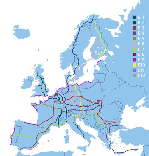
I have decided to follow the E5 at first. But what exactly is the E5?

I haven’t met anyone who was even heard of the E-paths here in France yet.

The ERA has a very crude map, Traildino has a not-so-crude map and some textual descriptions of the route. It mentions the GRs, to be taken in France, but that’s it. I haven’t found any comprehensive guide about the E5.

So, what am I going to do? I compare the maps and the description in Traildino with the maps on GR-Infos and build the route based on that.

To download the GPS track from GR-Infos I use “view-source:” in Google Chrome, and look for the Google Maps link. Then I remove the “embed” part of the link and get a description about the individual route in Google Maps. I can then download the KML file and use OSMNavigator or Google Earth on my smartphone to guide myself.

Now I hardly get lost and I’m building my route as I go =).

Traildino

The ERA website suggests we go to their partner website, Traildino, to get more information on the european routes. Indeed, in the ERA website, there’s close to no information on the routes themselves, except for a really crude map.

Traildino has a lot of information about hiking trails all around the world. It has comments, ratings, some maps, references and links to experiences on the trails.

I am using Traildino to set up my route on a big scale. I see which “Grande Randonée” the E5 corresponds to and look at those GRs individually.

Paris to Finistère

I should spend two more days hitch-hiking. One day to Rennes, and the next day to Finistère, to some place close to Pointe du Raz.

Paris to Rennes
Paris to Rennes

I’m still not sure where I’ll stay on the second day. It will depend on where I can find Couch Surfing hosts. Somewhere like Pont-Croix, Douarnenez, or Plogoff…

Rennes to Pont-Croix

Leaving for Brussels

On Thursday the 12th June I’ll hitch-hike to Brussels. Google Maps says that’s 771 km on the A2, which should take around 7 hours. But hitch-hiking can (and will) take much longer.

I’ll be leaving Berlin around 7 AM, and I’ll be really happy if I can make it to Brussels on the same day. I will be meeting some friends there, but they leave on Saturday morning.

I will try my chance on CouchSurfing in Brussels (and ask at a few other places along the way just to make sure I have a place to sleep in case I can’t make it to my destination in one day). Needless to say, I am still unprepared and haven’t put together most of the gear I’ll need in my journey. This extended weekend in Berlin was exhausting, I didn’t get much done…

The Route pt. 2

European long-distance paths cross Europe many times over. From north to south or west to east or whatever you want, you’ll find a path. Those paths are designated by the European Ramblers’ Association and seem (in principle) very nice.

European long-distance paths

Unfortunately, following these paths, I no longer get a straight line from point A to point B like in my first post about the route. But that was just a rough estimate. It was quite dumb actually =). Should I walk faster and finish the journey in 3 months or walk normally and probably take one month longer?

Anyways, I’m still in doubt where to start from. Pointe du Raz is the starting point of E5. It looks nice in Google Maps, maybe I can start from there?

Pointe du Raz: possible starting point?

Or I could start the Coastal Path E9 in Brest or Nantes. But starting in a city seems less fun than at Pointe du Raz. Also, in E9, it’s just coast all along, I might get bored…

So, should I start in E5 or  E9?

The Route pt. 1

“Crossing Europe by foot” is quite vague. I suppose I have to choose a route. I don’t have a clear idea for my start and end points, but I’m thinking about crossing both France and Germany. That means from the Western coast of France to the Eastern border of Germany.

Initial planned route on Google Maps.

Google Maps says that’s about 1600 km. If I walk on average 20 km per day, that should take me 80 days. We can round that up to 3 months. June, July, August.

Obviously I’ll have to research more into the fine details of which trails to follow, but I plan on asking hikers along the way for their advice and adapting my route accordingly.